Interval
Work since the previous summary
The work moved through six distinct prompt-led refinements after the earlier checkpoint. It began with information hierarchy on the game grid, expanded into a navigable world-and-region selector, and ended with a deliberate style-over-accuracy decision: approved illustrated globe and map artwork now drives the visible experience while structured game data continues to control interaction and lock state.
Direction of travel
How the work evolved.
Each step connects the user’s prompt to the practical change it produced.
Delivered
The target queue moved above a newly centred board
Prompt: Place target words below the level control, show no more than three rows, remove found words, refill from the top-left, and centre the remaining grid space in both directions.
Outcome: The target area became a stable three-row queue. Solved words disappear, queued words flow into the newly available space, and the board stays centred without drifting as targets are removed.
Delivered
A globe-to-dive navigation flow was established
Prompt: Create a swipe-rotatable globe with major reef markers, regional detail maps, locked and unlocked destinations, and a route back to the globe.
Outcome: The home action now opens a seven-region location selector. Available regions lead to detailed site maps, locked destinations block navigation, unlocked sites start a fresh campaign, and back navigation returns through the expected hierarchy.
Refined
Abstract maps were replaced by recognisable visual references
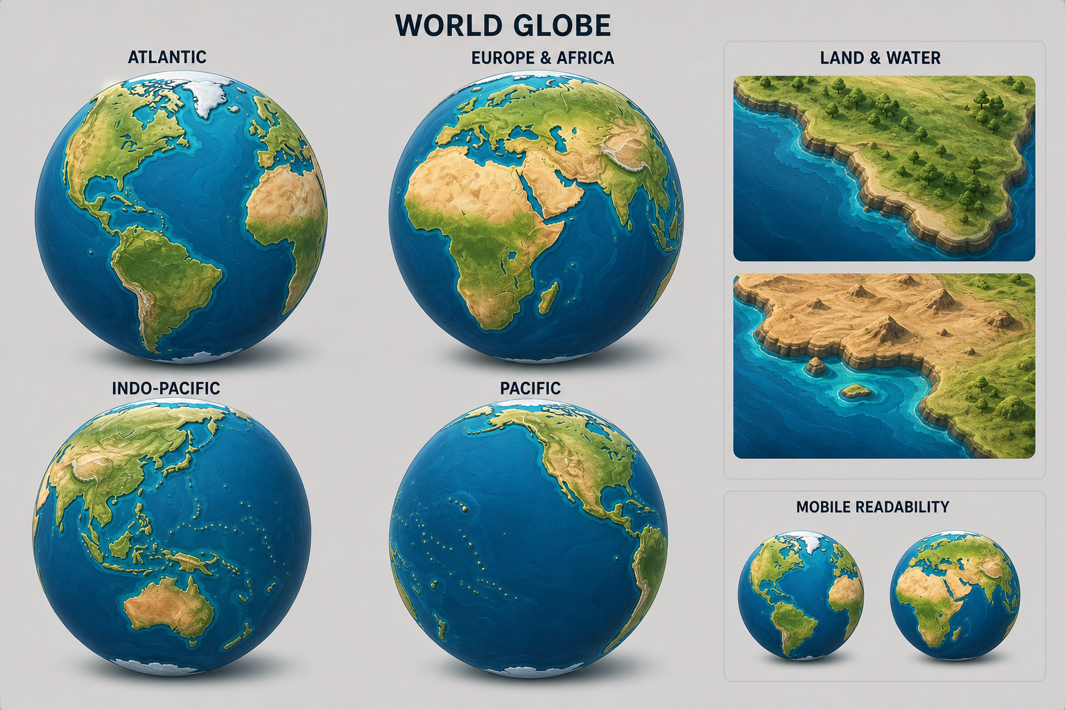
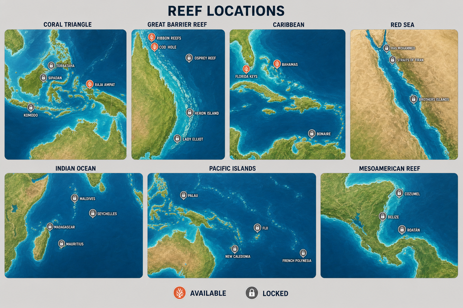
Prompt: Make the planet and individual locations recognisable rather than abstract, with accurate landmasses and placements, and create dedicated reference sheets for both scales.
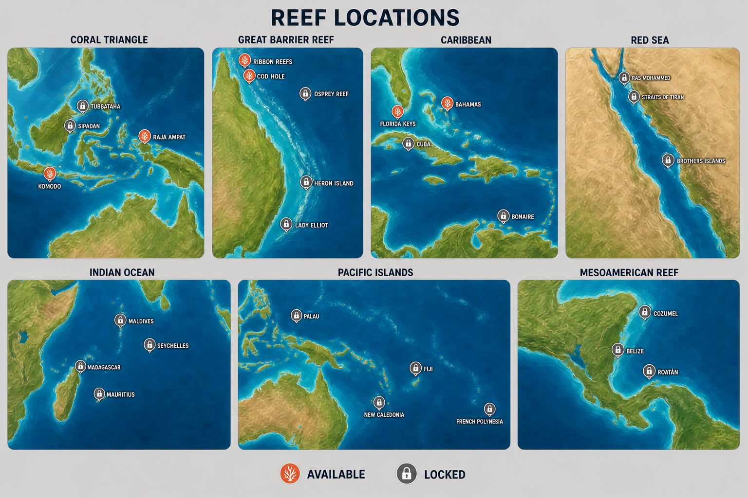
Outcome: A four-view globe board and a seven-region locations board were generated. A correction pass added a missing island location and fixed one destination-state marker before the references were offered for approval.
Approved
Approved references drove an accuracy-first implementation
Prompt: Promote the proposed sheets to the approved set and update the in-game graphics to match them.
Outcome: The first implementation adopted vetted geographic datasets, real coordinate placement, and improved clipping around horizons and date boundaries. This made landmasses and destination positions recognisable and testable.
Refined
Procedural maps received a dimensional styling pass
Prompt: Bring the globe and location maps closer to the approved art direction rather than presenting clean, flat vector cartography.
Outcome: Ocean depth, reef shelves, relief, biome variation, coastline treatments, painterly currents, and approved marker colours were added. A washed-out lighting layer was corrected during simulator review.
Direction settled
Approved artwork replaced visible procedural geography
Prompt: After side-by-side device feedback, make the globe 50% larger and prioritise the approved images over runtime geography, accepting some loss of continuous geographic accuracy to keep the presentation playful.
Outcome: The app now presents four authored globe rotations and approved regional map crops directly. Swipe navigation and interactive hotspots remain, marker sizing is protected from the globe scale change, and procedural geography is no longer part of the visible experience.
What improved
Improvements made.
Evidence-led changes grouped around the product, implementation, design and working process.
Predictable target-word flow
A fixed three-row target region now removes completed words and continuously refills from the top-left, keeping the next objectives easy to scan.
Balanced gameplay composition
The letter board is measured and centred inside the space left beneath the target queue, so its visual position remains stable as targets disappear.
Complete location-selection journey
Players can move from the home screen to a world view, into a regional map, and onward to an unlocked dive while retaining clear back navigation.
Structured progression rules
Region and dive-site availability are represented as game data rather than baked into the artwork, allowing locked markers to remain visible without becoming selectable.
Recognisable authored geography
The final visible maps use the approved globe and regional illustrations, preserving their terrain depth, water texture, labels, and destination language instead of approximating them with flat polygons.
Large globe without oversized controls
The globe is presented at 150% of its earlier scale with intentional edge cropping, while marker and hotspot behaviour remains readable and reachable through swiping.
Pain points
Friction, constraints and open edges.
Resolved problems are separated from constraints and work that remains open.
The first location screens were too abstract
The initial code-native globe and regional maps supported interaction but did not provide sufficiently familiar land shapes or site placement. Reference generation and a geography-backed pass corrected recognisability.
The first location board contained two content errors
One island destination was absent and one region marker used the wrong availability state. A precise edit retained the established board while correcting both details.
Accurate vectors still missed the approved style
Even after relief, currents, biome colour, and lighting were added, the result still read as procedural cartography. Device feedback showed that further primitive tuning would not reproduce the sculpted artwork, so visible rendering moved to the approved raster images.
Raster loading and scaling exposed edge cases
The first raster preview showed only overlays because named-image lookup did not resolve the bundled files. Explicit resource loading fixed that issue; crop shadow intrusion and accidentally enlarged markers were then corrected separately.
Outputs & proof
What was delivered and verified.
Each major direction was checked through focused tests, full-suite regressions, compiled builds, and simulator review. Test coverage grew with the location model and final asset integration, ending with 62 passing tests and a successful production-style build.
Verification record
- The three-row target queue was checked at a high target count and again after a word was removed; the queue refilled from the top-left while the board kept its centred region.
- Globe rotation, marker selection, locked-state blocking, region navigation, and return navigation were covered by focused model tests.
- Recognisable geography and coordinate-centred markers were visually reviewed on both globe and detailed regional screens before the approach changed to approved artwork.
- The approved raster globe and regional map were visually checked at the larger presentation scale, including crop boundaries and marker readability.
- The final interval ended with 62 passing tests and a successful production-style build.
Key decisions
Found target words disappear instead of being struck through, allowing queued targets to take their place.
The target region reserves a stable height within a level so word removal does not make the board jump.
Interaction and lock state remain structured game data even when the visible map is authored artwork.
Four authored globe rotations replace continuous polygon rendering, preserving swipe discovery while matching the approved visual language.
Playful consistency with the approved artwork takes precedence over continuously generated geographic precision.
Visual checkpoints
Generated and edited images.
Three visual-development outputs record the key prompt refinement: an authored globe system, the first regional locations board, and the corrected regional board that was subsequently approved. User-supplied screenshots are intentionally excluded because they were review inputs rather than generated outputs.
Next moves & open questions
Current position.
The product now has a stable three-row target queue, a centred gameplay board, and a complete Home → Globe → Region → Dive path. Location selection presents the approved illustrated globe at the larger scale and approved regional map crops, while structured hotspots preserve navigation and lock rules. The final checks passed; the changes remain local and ready for review or the normal project release workflow.